Located in San Juan County, Utah, Cave Spring: Water to Live By is a cave. It lies in or next to Canyonlands National Park, so park hours, fees and rules apply. The nearest town is Monticello, about 48 km (30 mi) away (Cave Spring: Water to Live By lies NW of town).
From the National Park Service
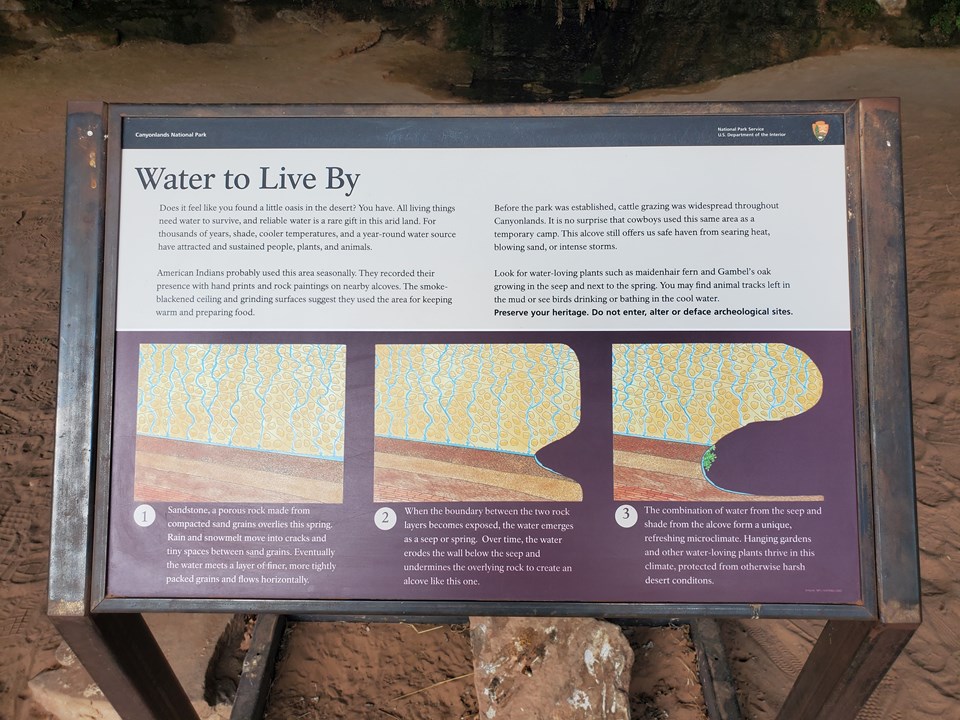
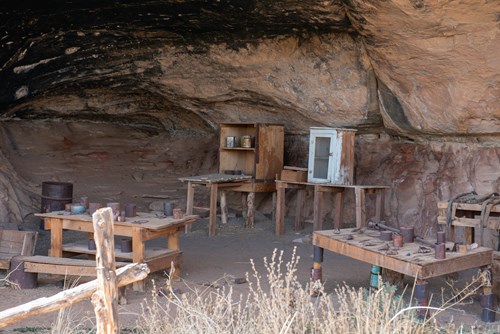
Does it feel like you found a little oasis in the desert? You have. All living things need water to survive, and reliable water is a rare gift in this arid land. For thousands of years, shade, cooler temperatures, and a year-round water source have attracted and sustained people, plants, and animals. American Indians probably used this area seasonally. They recorded their presence with hand prints and rock paintings on nearby alcoves. The smoke-blackened ceiling and grinding surfaces suggest they used the area for keeping warm and preparing food. Before the park was established, cattle grazing was widespread throughout Canyonlands. It is no surprise that cowboys used this same area as a temporary camp. This alcove still offers us safe haven from searing heat, blowing sand, or intense storms. Look for water-loving plants such as maidenhair fern and Gambel's oak growing in the seep and next to the spring. You may find animal tracks left in the mud or see birds drinking or bathing in the cool water. Preserve your heritage. Do not enter, alter, or deface archaeological sites. Below the text are three diagrams that are labled one, two, and three respectively. Each image is accompanied by text. Sandstone, a porous rock made form compacted sand grains overlies this spring. Rain and snowmelt move into cracks and tiny spaces between sand grains. Eventually the water meets a layer of finer, more tightly packed grains and flows horizontally. When the boundary between the two rock layers becomes exposed, the water emerges as a seep or spring. Over time, the water erodes the wall below the seep and undermines the overlaying rock to create an alcove like this one. The combination of water from the seep and shade from the alcove form a unique, refreshing microclimate. Hanging gardens and other water-loving plants thrive in this climate, protected from otherwise harsh desert conditions.
Text: National Park Service (public domain) — nps.gov.
Sunrise & sunset directions
At Cave Spring: Water to Live By the sunrise point swings a long way through the year: about 59° (ENE) at the June solstice and 120° (ESE) in late December. Sunset moves from 301° (WNW) in June to 241° (WSW) in December, and the midday sun climbs to 75° in summer but only 28° in winter.
| Date | Sunrise | Azimuth | Sunset | Azimuth | Noon sun | Daylight |
|---|---|---|---|---|---|---|
| March equinox (Mar 20) | 7:23 AM | 90° E | 7:31 PM | 271° W | 52° | 12h 08m |
| June solstice (Jun 21) | 5:57 AM | 59° ENE | 8:46 PM | 301° WNW | 75° | 14h 49m |
| September equinox (Sep 22) | 7:07 AM | 89° E | 7:18 PM | 271° W | 52° | 12h 10m |
| December solstice (Dec 21) | 7:33 AM | 120° ESE | 5:03 PM | 241° WSW | 28° | 9h 30m |
Azimuth is measured clockwise from true north (90° = east, 270° = west). Computed for 2026; values change by less than a degree from year to year.
Golden hour & blue hour by month
Caves are lit artificially — show caves have fixed lighting, so a fast lens and high ISO beat flash, which flattens formations.
| Month (15th) | Blue hour starts | Sunrise | Golden hour ends | Golden hour starts | Sunset | Blue hour ends | Daylight |
|---|---|---|---|---|---|---|---|
| January | 7:06 AM | 7:35 AM | 8:15 AM | 4:43 PM | 5:23 PM | 5:52 PM | 9h 48m |
| February | 6:43 AM | 7:10 AM | 7:47 AM | 5:21 PM | 5:58 PM | 6:25 PM | 10h 48m |
| March | 7:05 AM | 7:31 AM | 8:06 AM | 6:52 PM | 7:26 PM | 7:53 PM | 11h 55m |
| April | 6:17 AM | 6:44 AM | 7:19 AM | 7:20 PM | 7:55 PM | 8:22 PM | 13h 11m |
| May | 5:40 AM | 6:09 AM | 6:47 AM | 7:46 PM | 8:23 PM | 8:53 PM | 14h 14m |
| June | 5:25 AM | 5:56 AM | 6:36 AM | 8:05 PM | 8:44 PM | 9:16 PM | 14h 48m |
| July | 5:38 AM | 6:09 AM | 6:47 AM | 8:04 PM | 8:42 PM | 9:13 PM | 14h 34m |
| August | 6:07 AM | 6:35 AM | 7:11 AM | 7:38 PM | 8:14 PM | 8:42 PM | 13h 39m |
| September | 6:35 AM | 7:02 AM | 7:36 AM | 6:54 PM | 7:29 PM | 7:55 PM | 12h 27m |
| October | 7:02 AM | 7:28 AM | 8:04 AM | 6:07 PM | 6:43 PM | 7:09 PM | 11h 14m |
| November | 6:33 AM | 7:01 AM | 7:40 AM | 4:29 PM | 5:08 PM | 5:36 PM | 10h 07m |
| December | 7:00 AM | 7:29 AM | 8:10 AM | 4:20 PM | 5:01 PM | 5:30 PM | 9h 32m |
Local time (America/Denver), including daylight saving time. Golden hour runs from about −4° to +6° solar altitude, so the morning golden hour begins during blue hour, before sunrise.
Milky Way & night sky
From Cave Spring: Water to Live By, the Milky Way core is visible in a dark sky from March through September. June gives the longest window (about 5.2 hours on a moonless night), and the core peaks around 23° above the southern horizon. Our light-pollution model puts the sky at about Bortle 1 (excellent dark-sky site), which is excellent for astrophotography.
| Month | Core visible (15th) | Hours | Max altitude | Direction |
|---|---|---|---|---|
| January | Below 10° in darkness | — | -2° | — |
| February | 5:16 AM – 5:36 AM | 0.3 | 13° | SE → SE |
| March | 4:24 AM – 5:54 AM | 1.5 | 19° | SE → SSE |
| April | 2:29 AM – 4:59 AM | 2.5 | 22° | SE → S |
| May | 12:29 AM – 4:19 AM | 3.8 | 23° | SE → SSW |
| June | 10:41 PM – 3:51 AM | 5.2 | 23° | SE → SSW |
| July | 10:34 PM – 2:34 AM | 4.0 | 23° | SSE → SW |
| August | 9:53 PM – 12:33 AM | 2.7 | 23° | S → SW |
| September | 8:58 PM – 10:28 PM | 1.5 | 19° | SSW → SW |
| October | 8:10 PM – 8:30 PM | 0.3 | 13° | SW → SW |
| November | Below 10° in darkness | — | 0° | — |
| December | Below 10° in darkness | — | -19° | — |
Window when the galactic core is at least 10° high during astronomical darkness on the 15th of each month. Pick nights within a few days of the new moon. Plan exact nights with the Milky Way planner.
Estimated sky darkness: 1 Bortle 1 — Excellent dark-sky site. The Milky Way casts faint shadows; zodiacal light and airglow are obvious. Modeled zenith brightness ≈ 21.94 mag/arcsec².
Weather & best season
Long-term NASA satellite data for this area show June as the clearest month (about 31% average cloud cover) and December as the cloudiest (56%). July is the warmest month and January the coldest, which matters for gear, snow access and how long batteries last at night.
Average cloud cover (%)
| Jan | Feb | Mar | Apr | May | Jun | Jul | Aug | Sep | Oct | Nov | Dec | |
|---|---|---|---|---|---|---|---|---|---|---|---|---|
| High °F | 59 | 62 | 77 | 85 | 98 | 102 | 104 | 100 | 98 | 87 | 73 | 59 |
| Low °F | -7 | -8 | 8 | 18 | 22 | 34 | 48 | 47 | 32 | 7 | 8 | -4 |
| Precip. (in) | 0.8 | 1.0 | 1.0 | 0.8 | 0.8 | 0.5 | 1.2 | 1.2 | 1.3 | 1.2 | 0.8 | 1.1 |
Monthly climatology for the surrounding 1° grid cell from NASA POWER (MERRA-2). Mountain sites can be colder and cloudier than the cell average.
Photography tips for this cave
- Never touch formations — skin oils stop their growth.
- Follow White-nose Syndrome decontamination rules where posted to protect bats.
- Many show caves restrict tripods on tours; ask in advance or bring a small beanbag.
- Use manual focus with focus peaking in low light.
- Bring a spare battery — cold weather and long exposures drain them fast.
Season: Cave interiors stay at a constant temperature year-round; summer tours fill up, so book ahead.
Suggested gear: Fast lens (f/1.8–f/2.8), High-ISO camera, Small beanbag. Work out exposures with the depth of field, ND filter and NPF rule calculators.
Permits, drones & access
National Park Service rules. Under federal law (54 U.S.C. 100905), still photography in National Park Service areas needs a permit only when it (1) takes place where members of the public are not allowed, (2) uses models, sets or props that are not part of the location's natural or cultural resources or administrative facilities, or (3) would cause the park to incur additional administrative costs to monitor the activity. Ordinary visitor and most landscape photography needs no permit. Commercial filming rules are separate and have changed in recent years — confirm current requirements with the park before a paid shoot.
Drones: Launching, landing or operating unmanned aircraft (drones) is prohibited in National Park Service units under a 2014 Superintendent's closure (36 CFR 1.5), except where a park has issued specific written approval. Flying from outside the boundary over park land can also violate park rules and disturb wildlife.
Nearby photo spots
Other locations within 25 km of Cave Spring: Water to Live By, closest first.
 Cave
 Dark Sky Place
 Natural ArchNatural Arch
 Natural Arch
 Canyon
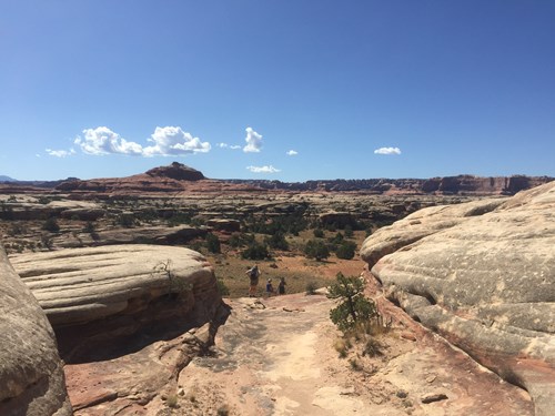 CanyonNatural Arch
 Waterfall
Campgrounds nearby (Recreation.gov)
- Canyonlands National Park Needles District Campground1.5 km (0.9 mi) · reservable
- Hamburger Rock Campground8.3 km (5.2 mi) · reservable
- Indian Creek Falls Group Site8.8 km (5.5 mi) · reservable
- Creek Pasture Group Site10.6 km (6.6 mi) · reservable
- Creek Pasture Campground10.7 km (6.6 mi) · reservable
FAQ
When is the best time to photograph Cave Spring: Water to Live By?
What time is golden hour at Cave Spring: Water to Live By?
Where does the sun rise and set at Cave Spring: Water to Live By?
Can you see the Milky Way from Cave Spring: Water to Live By?
Do you need a permit to photograph at Cave Spring: Water to Live By?
How far is Cave Spring: Water to Live By from Monticello?
Sources
Location data: National Park Service. Sun, moon and Milky Way times are computed by LWPhoto Atlas for 2026. Climate: NASA POWER. Sky darkness is a population-based estimate (Walker's law), not a measurement. See data sources & licenses.