
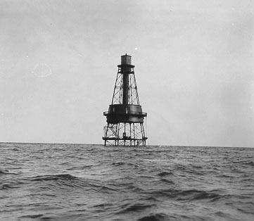
Located in Miami-Dade County, Florida, Pacific Reef Light is a lighthouse. It lies in or next to Biscayne National Park, so park hours, fees and rules apply. The nearest town is North Key Largo, about 22 km (13 mi) away (Pacific Reef Light lies ENE of town). Its recorded tower height is about 14 m (44 ft). It dates from 1921.
Wikidata describes it as: “lighthouse in the United States”.
Sunrise & sunset directions
At Pacific Reef Light the sunrise point swings a long way through the year: about 64° (ENE) at the June solstice and 116° (ESE) in late December. Sunset moves from 297° (WNW) in June to 244° (WSW) in December, and the midday sun climbs to 88° in summer but only 41° in winter.
| Date | Sunrise | Azimuth | Sunset | Azimuth | Noon sun | Daylight |
|---|---|---|---|---|---|---|
| March equinox (Mar 20) | 7:25 AM | 90° E | 7:32 PM | 270° W | 64° | 12h 07m |
| June solstice (Jun 21) | 6:32 AM | 64° ENE | 8:15 PM | 297° WNW | 88° | 13h 43m |
| September equinox (Sep 22) | 7:10 AM | 89° E | 7:18 PM | 271° W | 65° | 12h 08m |
| December solstice (Dec 21) | 7:03 AM | 116° ESE | 5:36 PM | 244° WSW | 41° | 10h 33m |
Azimuth is measured clockwise from true north (90° = east, 270° = west). Computed for 2026; values change by less than a degree from year to year.
Golden hour & blue hour by month
Lighthouses work at both ends of the day: blue hour when the beacon is lit, and golden hour when white towers take on warm tones.
| Month (15th) | Blue hour starts | Sunrise | Golden hour ends | Golden hour starts | Sunset | Blue hour ends | Daylight |
|---|---|---|---|---|---|---|---|
| January | 6:44 AM | 7:09 AM | 7:42 AM | 5:19 PM | 5:52 PM | 6:17 PM | 10h 44m |
| February | 6:33 AM | 6:56 AM | 7:28 AM | 5:44 PM | 6:15 PM | 6:38 PM | 11h 19m |
| March | 7:08 AM | 7:31 AM | 8:01 AM | 7:00 PM | 7:30 PM | 7:53 PM | 11h 59m |
| April | 6:35 AM | 6:59 AM | 7:29 AM | 7:13 PM | 7:44 PM | 8:07 PM | 12h 45m |
| May | 6:12 AM | 6:37 AM | 7:09 AM | 7:27 PM | 7:59 PM | 8:24 PM | 13h 23m |
| June | 6:05 AM | 6:31 AM | 7:04 AM | 7:40 PM | 8:13 PM | 8:39 PM | 13h 43m |
| July | 6:15 AM | 6:40 AM | 7:13 AM | 7:41 PM | 8:14 PM | 8:40 PM | 13h 34m |
| August | 6:31 AM | 6:55 AM | 7:26 AM | 7:26 PM | 7:57 PM | 8:21 PM | 13h 02m |
| September | 6:44 AM | 7:07 AM | 7:38 AM | 6:56 PM | 7:26 PM | 7:49 PM | 12h 19m |
| October | 6:56 AM | 7:20 AM | 7:50 AM | 6:24 PM | 6:54 PM | 7:17 PM | 11h 35m |
| November | 6:14 AM | 6:39 AM | 7:11 AM | 5:01 PM | 5:33 PM | 5:58 PM | 10h 55m |
| December | 6:34 AM | 7:00 AM | 7:34 AM | 5:00 PM | 5:34 PM | 5:59 PM | 10h 34m |
Local time (America/New York), including daylight saving time. Golden hour runs from about −4° to +6° solar altitude, so the morning golden hour begins during blue hour, before sunrise.
Milky Way & night sky
From Pacific Reef Light, the Milky Way core is visible in a dark sky from February through October. June gives the longest window (about 7.2 hours on a moonless night), and the core peaks around 36° above the southern horizon. Our light-pollution model puts the sky at about Bortle 4 (rural / suburban transition), good enough for detailed Milky Way images.
| Month | Core visible (15th) | Hours | Max altitude | Direction |
|---|---|---|---|---|
| January | Below 10° in darkness | — | 3° | — |
| February | 4:23 AM – 5:33 AM | 1.2 | 22° | SE → SE |
| March | 3:37 AM – 6:07 AM | 2.5 | 32° | SE → SSE |
| April | 1:33 AM – 5:33 AM | 4.0 | 36° | SE → S |
| May | 11:34 PM – 5:04 AM | 5.5 | 36° | SE → SSW |
| June | 9:43 PM – 4:53 AM | 7.2 | 36° | SE → SW |
| July | 9:42 PM – 3:32 AM | 5.8 | 36° | SSE → SW |
| August | 9:19 PM – 1:29 AM | 4.2 | 36° | S → SW |
| September | 8:43 PM – 11:23 PM | 2.7 | 33° | SSW → SW |
| October | 8:11 PM – 9:31 PM | 1.3 | 23° | SW → SW |
| November | Below 10° in darkness | — | 6° | — |
| December | Below 10° in darkness | — | -17° | — |
Window when the galactic core is at least 10° high during astronomical darkness on the 15th of each month. Pick nights within a few days of the new moon. Plan exact nights with the Milky Way planner.
Estimated sky darkness: 4 Bortle 4 — Rural / suburban transition. Light domes are visible in several directions; the Milky Way is clear but lacks detail near the horizon. Modeled zenith brightness ≈ 20.64 mag/arcsec².
Weather & best season
Long-term NASA satellite data for this area show November as the clearest month (about 46% average cloud cover) and June as the cloudiest (69%). August is the warmest month and January the coldest, which matters for gear, snow access and how long batteries last at night.
Average cloud cover (%)
| Jan | Feb | Mar | Apr | May | Jun | Jul | Aug | Sep | Oct | Nov | Dec | |
|---|---|---|---|---|---|---|---|---|---|---|---|---|
| High °F | 81 | 83 | 86 | 89 | 90 | 91 | 91 | 91 | 90 | 89 | 86 | 82 |
| Low °F | 37 | 43 | 48 | 58 | 67 | 76 | 78 | 79 | 73 | 57 | 53 | 41 |
| Precip. (in) | 1.4 | 1.8 | 1.7 | 2.8 | 4.7 | 8.1 | 7.1 | 7.4 | 8.0 | 4.2 | 2.2 | 1.7 |
Monthly climatology for the surrounding 1° grid cell from NASA POWER (MERRA-2). Mountain sites can be colder and cloudier than the cell average.
Photography tips for this lighthouse
- Moonrise or the Milky Way over the tower makes a classic night composition; plan with the azimuth tables.
- During blue hour, use 5–15 second exposures to capture the beam; check whether the light is still active.
- Shoot from the beach or a jetty to place the tower against open sky and sea.
- Stormy weather and crashing surf add drama; keep a safe distance from waves on rocks and piers.
- A telephoto from across a bay compresses the tower against cliffs or the moon.
- Check road and trail conditions with the managing agency before you go.
Season: Summer brings open towers and tours; autumn and winter offer storms, fewer crowds and lower sun angles.
Suggested gear: Tripod, Telephoto lens, ND filter for smooth water, Rain cover. Work out exposures with the depth of field, ND filter and NPF rule calculators.
Permits, drones & access
National Park Service rules. Under federal law (54 U.S.C. 100905), still photography in National Park Service areas needs a permit only when it (1) takes place where members of the public are not allowed, (2) uses models, sets or props that are not part of the location's natural or cultural resources or administrative facilities, or (3) would cause the park to incur additional administrative costs to monitor the activity. Ordinary visitor and most landscape photography needs no permit. Commercial filming rules are separate and have changed in recent years — confirm current requirements with the park before a paid shoot.
Drones: Launching, landing or operating unmanned aircraft (drones) is prohibited in National Park Service units under a 2014 Superintendent's closure (36 CFR 1.5), except where a park has issued specific written approval. Flying from outside the boundary over park land can also violate park rules and disturb wildlife.
Tides
The nearest NOAA tide prediction station is Billys Point, south of, Elliott Key, Biscayne Bay, 8.4 km (5.2 mi) away. Low tide often reveals tide pools, wet-sand reflections and sea stacks.
Nearby photo spots
Other locations within 25 km of Pacific Reef Light, closest first.
 Lighthouse
 Lighthouse
 National Wildlife Refuge
 Lighthouse
Campgrounds nearby (Recreation.gov)
- Elliot Key Campground10.7 km (6.6 mi) · reservable
- Boca Chita Campground17.3 km (10.7 mi) · reservable
FAQ
When is the best time to photograph Pacific Reef Light?
What time is golden hour at Pacific Reef Light?
Where does the sun rise and set at Pacific Reef Light?
Can you see the Milky Way from Pacific Reef Light?
Do you need a permit to photograph at Pacific Reef Light?
How far is Pacific Reef Light from North Key Largo?
Sources
Location data: Wikidata, USGS GNIS / GeoNames. Sun, moon and Milky Way times are computed by LWPhoto Atlas for 2026. Climate: NASA POWER. Sky darkness is a population-based estimate (Walker's law), not a measurement. See data sources & licenses.