Top volcanoes
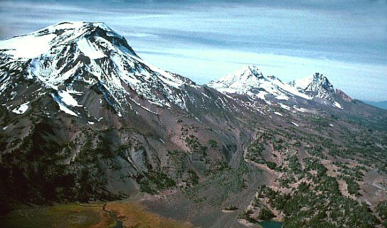 Volcano
Three Sisters
 Volcano
Newberry Volcano
 Volcano
Fort Rock
 Volcano
Pilot Butte
 Volcano
Blue Lake Crater
 Volcano
Crack in the Ground
 Volcano
Davis Lake volcanic field
 Volcano
Mount Tabor
VolcanoChina Hat
VolcanoBelknap Crater
VolcanoBig Hole
VolcanoBlack Crater
Volcanoes by county
All volcanoes (30)
| Name | County | Elevation | Nearest town | Sky |
|---|---|---|---|---|
| Three Sisters | Deschutes County | — | Sisters | 2 |
| Newberry Volcano | Deschutes County | — | La Pine | 2 |
| Fort Rock | Lake County | — | La Pine | 1 |
| Pilot Butte | Deschutes County | — | Bend | 7 |
| Blue Lake Crater | Deschutes County | — | Sisters | 2 |
| Crack in the Ground | Lake County | — | Deschutes River Woods | 1 |
| Davis Lake volcanic field | Klamath County | — | La Pine | 2 |
| Mount Tabor | Multnomah County | — | Lents | 7 |
| China Hat | Deschutes County | — | La Pine | 2 |
| Belknap Crater | Linn County | 2,066 m | Sisters | 2 |
| Big Hole | Lake County | 1,406 m | La Pine | 2 |
| Black Crater | Deschutes County | 1,988 m | Sisters | 2 |
| Bowden Crater | Malheur County | 1,413 m | Nampa | 1 |
| Cayuse Crater | Deschutes County | 2,234 m | Sisters | 3 |
| Coffeepot Crater | Malheur County | 1,373 m | Nampa | 2 |
| Diamond Crater | Klamath County | 1,406 m | Klamath Falls | 1 |
| Diamond Craters | Harney County | 1,310 m | Hines | 1 |
| Harlow Crater | Lane County | 1,892 m | Sisters | 2 |
| Jordan Craters | Malheur County | 1,345 m | Nampa | 2 |
| Latta Crater | Deschutes County | 1,901 m | Sisters | 2 |
| Le Conte Crater | Deschutes County | 1,985 m | Sisters | 2 |
| Little Nash Crater | Linn County | 1,196 m | Sisters | 2 |
| Millican Crater | Deschutes County | 1,960 m | Sisters | 2 |
| Newberry Crater | Deschutes County | 2,117 m | Three Rivers | 2 |
| Red Crater | Deschutes County | 1,584 m | Sunriver | 2 |
| Timber CraterCrater Lake | Klamath County | 2,231 m | Eagle Point | 1 |
| Twin Craters | Lane County | 1,567 m | Sisters | 2 |
| West Crater | Malheur County | 1,337 m | Nampa | 1 |
| Witches CauldronCrater Lake | Klamath County | 2,093 m | Eagle Point | 2 |
| Yapoah Crater | Lane County | 2,045 m | Sisters | 2 |
Sky = estimated Bortle class (1 darkest – 9 brightest).
Map
How to photograph volcanoes
Volcanic cones and lava fields have strong shapes that read well in side-light; dark basalt needs careful exposure.
- Snow-capped volcanoes reflect alpenglow at sunrise — shoot from a lake or meadow for a reflection.
- Lava rock is sharp and unstable; stay on trails.
- Long lenses from 20–60 miles away make large stratovolcanoes dominate the horizon.
- Check local volcanic activity notices and area closures before visiting.
Season: Summer for high trails; winter and spring for snowy cones viewed from below.