
Located in Beaverhead County, Montana, Big Hole Pass is a mountain pass at about 2,151 m (7,057 ft) above sea level. It is part of Beaverhead–Deerlodge National Forest. It sits roughly 42 km (26 mi) N of Salmon.
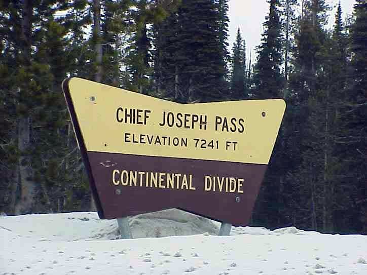
Big Hole Pass (elevation: 7,055 feet (2,150 m)) is a high mountain pass in the northern Rocky Mountains of the western United States. It is on the Montana–Idaho border, approximately eight miles (13 km) due south of Montana State Highway 43 in the Beaverhead–Deerlodge National Forest in Beaverhead County, Montana, and Salmon National Forest in Lemhi County, Idaho. Note: This location should not be confused with Big Hole Pass on Montana Highway 278 (between Wisdom and Polaris) at the height of land west of Dillon, that denotes the eastern entrance to the Big Hole valley. The Continental Divide Trail goes over this pass, which is about eleven miles (18 km) south-southeast of the more famous Chief Joseph Pass. The pass can be approached from Gibbonsville, Idaho on a gravel Forest Service road, Dahlonega Creek Road #079, from the west or Forest Service Roads #943 and #624 from Highway 43...From the Wikipedia article “Big Hole Pass”, licensed under CC BY-SA 4.0.
Sunrise & sunset directions
At Big Hole Pass the sunrise point swings a long way through the year: about 55° (NE) at the June solstice and 124° (SE) in late December. Sunset moves from 306° (NW) in June to 237° (WSW) in December, and the midday sun climbs to 68° in summer but only 21° in winter.
| Date | Sunrise | Azimuth | Sunset | Azimuth | Noon sun | Daylight |
|---|---|---|---|---|---|---|
| March equinox (Mar 20) | 7:39 AM | 90° E | 7:48 PM | 271° W | 44° | 12h 09m |
| June solstice (Jun 21) | 5:47 AM | 55° NE | 9:29 PM | 306° NW | 68° | 15h 41m |
| September equinox (Sep 22) | 7:23 AM | 89° E | 7:35 PM | 271° W | 45° | 12h 12m |
| December solstice (Dec 21) | 8:13 AM | 124° SE | 4:55 PM | 237° WSW | 21° | 8h 42m |
Azimuth is measured clockwise from true north (90° = east, 270° = west). Computed for 2026; values change by less than a degree from year to year.
Golden hour & blue hour by month
Mountain passes sit above valleys, so they reward sunrise and sunset with layered ridges, valley fog and long shadows.
| Month (15th) | Blue hour starts | Sunrise | Golden hour ends | Golden hour starts | Sunset | Blue hour ends | Daylight |
|---|---|---|---|---|---|---|---|
| January | 7:39 AM | 8:12 AM | 9:00 AM | 4:31 PM | 5:18 PM | 5:51 PM | 9h 06m |
| February | 7:08 AM | 7:38 AM | 8:20 AM | 5:21 PM | 6:03 PM | 6:33 PM | 10h 24m |
| March | 7:19 AM | 7:49 AM | 8:28 AM | 7:02 PM | 7:41 PM | 8:11 PM | 11h 53m |
| April | 6:19 AM | 6:50 AM | 7:30 AM | 7:42 PM | 8:21 PM | 8:52 PM | 13h 31m |
| May | 5:31 AM | 6:05 AM | 6:48 AM | 8:17 PM | 9:00 PM | 9:34 PM | 14h 54m |
| June | 5:09 AM | 5:47 AM | 6:32 AM | 8:41 PM | 9:27 PM | 10:05 PM | 15h 40m |
| July | 5:25 AM | 6:02 AM | 6:46 AM | 8:38 PM | 9:22 PM | 9:59 PM | 15h 21m |
| August | 6:04 AM | 6:37 AM | 7:18 AM | 8:04 PM | 8:45 PM | 9:17 PM | 14h 08m |
| September | 6:45 AM | 7:15 AM | 7:54 AM | 7:09 PM | 7:48 PM | 8:18 PM | 12h 34m |
| October | 7:22 AM | 7:52 AM | 8:33 AM | 6:11 PM | 6:51 PM | 7:21 PM | 10h 59m |
| November | 7:03 AM | 7:35 AM | 8:21 AM | 4:21 PM | 5:06 PM | 5:38 PM | 9h 31m |
| December | 7:35 AM | 8:10 AM | 8:59 AM | 4:04 PM | 4:53 PM | 5:27 PM | 8h 43m |
Local time (America/Denver), including daylight saving time. Golden hour runs from about −4° to +6° solar altitude, so the morning golden hour begins during blue hour, before sunrise.
Milky Way & night sky
From Big Hole Pass, the Milky Way core is visible in a dark sky from April through August. June gives the longest window (about 3.0 hours on a moonless night), and the core peaks around 16° above the southern horizon. Our light-pollution model puts the sky at about Bortle 1 (excellent dark-sky site), which is excellent for astrophotography.
| Month | Core visible (15th) | Hours | Max altitude | Direction |
|---|---|---|---|---|
| January | Below 10° in darkness | — | -4° | — |
| February | Below 10° in darkness | — | 7° | — |
| March | 5:40 AM – 6:00 AM | 0.3 | 12° | SSE → SSE |
| April | 3:40 AM – 4:50 AM | 1.2 | 15° | SSE → SSE |
| May | 1:40 AM – 3:50 AM | 2.2 | 16° | SSE → S |
| June | 12:03 AM – 3:03 AM | 3.0 | 16° | SSE → SSW |
| July | 11:46 PM – 1:46 AM | 2.0 | 16° | S → SSW |
| August | 10:41 PM – 11:51 PM | 1.2 | 14° | SSW → SSW |
| September | 9:30 PM – 9:50 PM | 0.3 | 12° | SSW → SSW |
| October | Below 10° in darkness | — | 7° | — |
| November | Below 10° in darkness | — | -3° | — |
| December | Below 10° in darkness | — | -20° | — |
Window when the galactic core is at least 10° high during astronomical darkness on the 15th of each month. Pick nights within a few days of the new moon. Plan exact nights with the Milky Way planner.
Estimated sky darkness: 1 Bortle 1 — Excellent dark-sky site. The Milky Way casts faint shadows; zodiacal light and airglow are obvious. Modeled zenith brightness ≈ 21.94 mag/arcsec². Aurora needs roughly Kp 5.0+ to show low on the northern horizon here.
Weather & best season
Long-term NASA satellite data for this area show July as the clearest month (about 36% average cloud cover) and March as the cloudiest (71%). July is the warmest month and January the coldest, which matters for gear, snow access and how long batteries last at night.
Average cloud cover (%)
| Jan | Feb | Mar | Apr | May | Jun | Jul | Aug | Sep | Oct | Nov | Dec | |
|---|---|---|---|---|---|---|---|---|---|---|---|---|
| High °F | 40 | 46 | 61 | 71 | 83 | 88 | 97 | 92 | 87 | 77 | 62 | 41 |
| Low °F | -30 | -31 | -17 | 0 | 13 | 22 | 31 | 30 | 20 | -4 | -21 | -25 |
| Precip. (in) | 2.2 | 2.2 | 2.2 | 2.3 | 2.6 | 2.8 | 1.0 | 1.2 | 1.6 | 1.7 | 2.0 | 2.3 |
Monthly climatology for the surrounding 1° grid cell from NASA POWER (MERRA-2). Mountain sites can be colder and cloudier than the cell average.
Photography tips for this mountain pass
- Look for the road itself as a leading line — switchbacks from above make strong compositions.
- Weather changes fast at elevation; carry layers even in summer.
- Summit pull-outs often face one direction; use the sun azimuth table to see whether sunrise or sunset suits the view.
- Wildflowers bloom late at pass elevations — often July to early August in the Rockies and Sierra.
- Check road status before driving: many high passes close seasonally or after storms.
- Tell someone where you're going in remote areas and carry the ten essentials.
Season: Summer and early autumn are the main season; winter visits depend on plowing and avalanche conditions.
Suggested gear: Telephoto lens, Tripod, Warm layers, Road-condition app. Work out exposures with the depth of field, ND filter and NPF rule calculators.
Nearby photo spots
Other locations within 25 km of Big Hole Pass, closest first.
Campgrounds nearby (Recreation.gov)
- May Creek Cabin10.3 km (6.4 mi) · reservable
- Twin Creek Campground Group Camping Site13.4 km (8.3 mi) · reservable
- Gordon Reese Cabin18.4 km (11.4 mi) · reservable
- Twin Lakes Cabin (Mt)18.7 km (11.6 mi) · reservable
- Hogan Cabin18.8 km (11.7 mi) · reservable
FAQ
When is the best time to photograph Big Hole Pass?
What time is golden hour at Big Hole Pass?
Where does the sun rise and set at Big Hole Pass?
Can you see the Milky Way from Big Hole Pass?
Do you need a permit to photograph at Big Hole Pass?
How far is Big Hole Pass from Salmon?
Sources
Location data: Wikidata, USGS GNIS / GeoNames, Wikipedia. Sun, moon and Milky Way times are computed by LWPhoto Atlas for 2026. Climate: NASA POWER. Sky darkness is a population-based estimate (Walker's law), not a measurement. See data sources & licenses.