
Top mountain peaks
 Mountain Peak
Mount Mazama
 Mountain Peak
Mount Hood
 Mountain Peak
Mount Bachelor
 Mountain Peak
Mount Jefferson
 Mountain Peak
Mount McLoughlin
 Mountain Peak
Mount Thielsen
 Mountain Peak
Roxy Ann Peak
 Mountain Peak
Three Fingered Jack
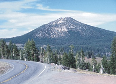 Mountain Peak
Mount Scott
 Mountain Peak
Sacajawea Peak
 Mountain Peak
Mount Bailey
 Mountain Peak
Broken Top
Mountain Peaks by county
All mountain peaks (41)
| Name | County | Elevation | Nearest town | Sky |
|---|---|---|---|---|
| Mount MazamaCrater Lake | Klamath County | 1,885 m | Eagle Point | 2 |
| Mount Hood | Hood River County | 3,425 m | Mount Hood Village | 3 |
| Mount Bachelor | Deschutes County | 2,759 m | Sunriver | 3 |
| Mount Jefferson | Linn County | 3,189 m | Warm Springs | 2 |
| Mount McLoughlin | Jackson County | 2,895 m | Eagle Point | 2 |
| Mount ThielsenCrater Lake | Douglas County | 2,783 m | Eagle Point | 2 |
| Roxy Ann Peak | Jackson County | 1,089 m | Medford | 5 |
| Three Fingered Jack | Jefferson County | 2,121 m | Sisters | 2 |
| Mount ScottCrater Lake | Klamath County | 2,636 m | Klamath Falls | 1 |
| Sacajawea Peak | Wallowa County | 2,975 m | Joseph | 1 |
| Mount BaileyCrater Lake | Douglas County | 2,551 m | Eagle Point | 2 |
| Broken Top | Deschutes County | 2,756 m | Sisters | 3 |
| Mount Washington | Linn County | 2,346 m | Sisters | 2 |
| Diamond Peak | Lane County | 2,644 m | Oakridge | 2 |
| Mount Ashland | Jackson County | 2,283 m | Ashland | 3 |
| Yamsay Mountain | Klamath County | 2,468 m | Klamath Falls | 1 |
| Black Butte | Jefferson County | 1,937 m | Sisters | 2 |
| Tumalo Mountain | Deschutes County | 2,370 m | Sunriver | 3 |
| Painted Hills | Wheeler County | 671 m | Prineville | 2 |
| Steens Mountain | Harney County | — | Caldwell | 1 |
| Hoodoo Butte | Linn County | 1,706 m | Sisters | 2 |
| Strawberry Mountain | Grant County | 2,750 m | John Day | 1 |
| Cinnamon Butte | Douglas County | 1,957 m | Cottage Grove | 2 |
| Maiden Peak | Deschutes County | 2,380 m | La Pine | 2 |
| Hayrick Butte | Linn County | 1,671 m | Sisters | 2 |
| Malheur Butte | Malheur County | 790 m | Ontario | 3 |
| Mount Scott | Clackamas County | 333 m | Happy Valley | 7 |
| Bohemia Mountain | Lane County | 1,823 m | Culp Creek | 2 |
| Paulina Peak | Deschutes County | 2,429 m | La Pine | 2 |
| Union PeakCrater Lake | Klamath County | 2,315 m | Shady Cove | 2 |
| Mount Sylvania | Multnomah County | 290 m | Metzger | 8 |
| Mahogany Mountain | Malheur County | 1,985 m | Marsing | 2 |
| Larch Mountain | Multnomah County | 1,203 m | Sandy | 4 |
| Mount Howard | Wallowa County | 2,512 m | Joseph | 1 |
| Rocky Butte | Multnomah County | 183 m | Lents | 7 |
| Saddle Mountain | Clatsop County | 1,004 m | Gearhart | 3 |
| Pelican Butte | Klamath County | 2,440 m | Klamath Falls | 2 |
| Hager Mountain | Lake County | 2,188 m | Altamont | 1 |
| Cooper Mountain | Washington County | 237 m | Aloha | 7 |
| Eagle Cap | Union County | 2,909 m | Joseph | 1 |
| Grizzly Mountain | Crook County | 1,710 m | Prineville | 3 |
Sky = estimated Bortle class (1 darkest – 9 brightest).
Map
How to photograph mountain peaks
Summits catch first and last light — alpenglow can turn rock pink or orange minutes before sunrise and after sunset while valleys stay in shadow.
- Photograph the peak from a lake, meadow or ridge at sunrise when the face that looks east lights up first.
- Long lenses compress ridgelines; shoot the peak from several miles away to make it look massive.
- Afternoon thunderstorms are common in summer at high elevations — plan summit hikes for early morning.
- Snow on the summit holds detail best when you expose for the highlights and lift shadows later.
- Alpenglow lasts only a few minutes; set up and focus beforehand.
Season: Early summer keeps snow on the peaks with green valleys below; autumn adds aspen or larch color in many ranges.