
Top mountain peaks
 Mountain Peak
Grand Teton
 Mountain Peak
Devils Tower
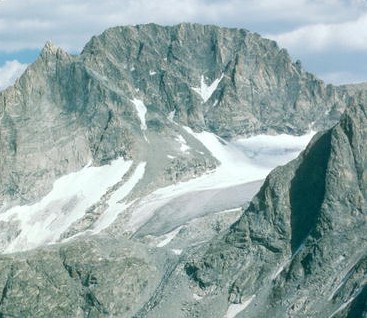 Mountain Peak
Gannett Peak
 Mountain Peak
Mount Moran
 Mountain Peak
Cloud Peak
 Mountain Peak
Mount Washburn
 Mountain Peak
Mount Owen
 Mountain Peak
Middle Teton
 Mountain Peak
Francs Peak
 Mountain Peak
Eagle Peak
 Mountain Peak
Mount Holmes
 Mountain Peak
Casper Mountain
Mountain Peaks by county
All mountain peaks (84)
| Name | County | Elevation | Nearest town | Sky |
|---|---|---|---|---|
| Grand TetonGrand Teton | Teton County | 4,200 m | Moose Wilson Road | 1 |
| Devils TowerDevils Tower | Crook County | 1,559 m | Sundance | 1 |
| Gannett Peak | Fremont County | 4,207 m | Pinedale | 1 |
| Mount MoranGrand Teton | Teton County | 3,837 m | Driggs | 1 |
| Cloud Peak | Big Horn County | 4,017 m | Buffalo | 1 |
| Mount WashburnYellowstone | Park County | 3,116 m | West Yellowstone | 1 |
| Mount OwenGrand Teton | Teton County | 3,934 m | Moose Wilson Road | 1 |
| Middle TetonGrand Teton | Teton County | 3,904 m | Moose Wilson Road | 1 |
| Francs Peak | Park County | 3,801 m | Cody | 1 |
| Eagle PeakYellowstone | Park County | 3,460 m | Cody | 1 |
| Mount HolmesYellowstone | Park County | 3,149 m | West Yellowstone | 1 |
| Casper Mountain | Natrona County | 2,390 m | Mills | 3 |
| Colter PeakYellowstone | Park County | 3,243 m | Cody | 1 |
| Mount NorrisYellowstone | Park County | 3,000 m | Cody | 1 |
| Mount SheridanYellowstone | Teton County | 3,139 m | Jackson | 1 |
| Fremont Peak | Fremont County | 4,177 m | Pinedale | 1 |
| Mount HancockYellowstone | Teton County | 3,116 m | Jackson | 1 |
| Antler PeakYellowstone | Park County | 3,048 m | West Yellowstone | 1 |
| Barlow PeakYellowstone | Teton County | 2,929 m | Jackson | 1 |
| Mount EvertsYellowstone | Park County | 2,387 m | West Yellowstone | 1 |
| Mount SchurzYellowstone | Park County | 3,355 m | Cody | 1 |
| Mount StevensonYellowstone | Park County | 3,118 m | Cody | 1 |
| Barronette PeakYellowstone | Park County | 3,156 m | Livingston | 1 |
| South TetonGrand Teton | Teton County | 3,801 m | Moose Wilson Road | 1 |
| Roaring MountainYellowstone | Park County | 2,485 m | West Yellowstone | 1 |
| Buck MountainGrand Teton | Teton County | 3,627 m | Moose Wilson Road | 2 |
| Bunsen PeakYellowstone | Park County | 2,599 m | West Yellowstone | 1 |
| Teewinot MountainGrand Teton | Teton County | 3,733 m | Moose Wilson Road | 1 |
| Terrace MountainYellowstone | Park County | 2,439 m | West Yellowstone | 1 |
| Wind River Peak | Sublette County | 3,999 m | Lander | 1 |
| Echo PeakYellowstone | Park County | 2,917 m | West Yellowstone | 1 |
| Gray PeakYellowstone | Park County | 3,139 m | West Yellowstone | 1 |
| Younts Peak | Park County | 3,691 m | Cody | 1 |
| Mount HaynesYellowstone | Teton County | 2,505 m | West Yellowstone | 1 |
| Mount LangfordYellowstone | Park County | 3,238 m | Cody | 1 |
| Abiathar PeakYellowstone | Park County | 3,331 m | Livingston | 1 |
| Laramie Peak | Albany County | 3,059 m | Wheatland | 1 |
| Mount Saint JohnGrand Teton | Teton County | 3,469 m | Driggs | 1 |
| Bivouac PeakGrand Teton | Teton County | 3,296 m | Driggs | 1 |
| Sepulcher Mountain | Park County | 2,939 m | West Yellowstone | 1 |
| Sheep Mountain | Teton County | 3,418 m | Jackson | 2 |
| Purple MountainYellowstone | Teton County | 2,558 m | West Yellowstone | 1 |
| Mount WoodringGrand Teton | Teton County | 3,514 m | Driggs | 1 |
| National Park Mountain | Teton County | 2,300 m | West Yellowstone | 1 |
| The ThundererYellowstone | Park County | 3,199 m | Cody | 1 |
| Clagett ButteYellowstone | Park County | 2,451 m | West Yellowstone | 1 |
| Disappointment PeakGrand Teton | Teton County | 3,529 m | Moose Wilson Road | 1 |
| Dunraven PeakYellowstone | Park County | 3,008 m | West Yellowstone | 1 |
| Elk Mountain | Carbon County | 3,390 m | Saratoga | 1 |
| Elk MountainGrand Teton | Teton County | 3,268 m | Driggs | 1 |
| Factory HillYellowstone | Teton County | 2,904 m | Jackson | 1 |
| Medicine Bow Peak | Albany County | 3,639 m | Saratoga | 2 |
| Heart Mountain | Park County | 2,387 m | Cody | 2 |
| Hedges PeakYellowstone | Park County | 2,947 m | West Yellowstone | 1 |
| Mount Sacagawea | Fremont County | 4,119 m | Pinedale | 1 |
| Union Peak, Wyoming | Sublette County | 3,501 m | Jackson | 1 |
| Whiskey Mountain | Fremont County | 3,394 m | Jackson | 1 |
| War Bonnet Peak | Sublette County | 3,716 m | Fort Washakie | 1 |
| Bannock PeakYellowstone | Park County | 3,137 m | West Yellowstone | 1 |
| Battleship MountainGrand Teton | Teton County | 3,197 m | Driggs | 1 |
| Prospectors MountainGrand Teton | Teton County | 3,417 m | Moose Wilson Road | 2 |
| Mount WisterGrand Teton | Teton County | 3,493 m | Moose Wilson Road | 1 |
| Nez Perce PeakGrand Teton | Teton County | 3,612 m | Moose Wilson Road | 1 |
| Rockchuck PeakGrand Teton | Teton County | 3,381 m | Driggs | 1 |
| Black Tooth Mountain | Big Horn County | 3,732 m | Buffalo | 1 |
| Mount Woolsey | Big Horn County | 3,942 m | Buffalo | 1 |
| Static PeakGrand Teton | Teton County | 3,417 m | Moose Wilson Road | 2 |
| Thor PeakGrand Teton | Teton County | 3,659 m | Driggs | 1 |
| Owl PeakGrand Teton | Teton County | 3,229 m | Driggs | 1 |
| Wyoming Peak | Lincoln County | 3,442 m | Afton | 1 |
| Pingora Peak | Fremont County | 3,607 m | Fort Washakie | 1 |
| White Mountain | Sweetwater County | 2,321 m | North Rock Springs | 4 |
| White PeaksYellowstone | Park County | 2,887 m | West Yellowstone | 1 |
| Druid PeakYellowstone | Park County | 2,919 m | Livingston | 1 |
| Eagles Rest PeakGrand Teton | Teton County | 3,417 m | Driggs | 1 |
| Jackson Peak | Fremont County | 4,114 m | Pinedale | 1 |
| Mount HornadayYellowstone | Park County | 3,049 m | Livingston | 1 |
| Inyan Kara Mountain | Crook County | 1,935 m | Sundance | 1 |
| Mount Bonneville | Sublette County | 3,730 m | Fort Washakie | 1 |
| Warrior Peaks | Sublette County | 3,744 m | Fort Washakie | 1 |
| Ranger PeakGrand Teton | Teton County | 3,454 m | Driggs | 1 |
| Table MountainGrand Teton | Teton County | 3,372 m | Driggs | 1 |
| Lizard Head Peak | Fremont County | 3,799 m | Fort Washakie | 1 |
| Wilkins Peak | Sweetwater County | 2,294 m | Green River | 3 |
Sky = estimated Bortle class (1 darkest – 9 brightest).
Map
How to photograph mountain peaks
Summits catch first and last light — alpenglow can turn rock pink or orange minutes before sunrise and after sunset while valleys stay in shadow.
- Photograph the peak from a lake, meadow or ridge at sunrise when the face that looks east lights up first.
- Long lenses compress ridgelines; shoot the peak from several miles away to make it look massive.
- Afternoon thunderstorms are common in summer at high elevations — plan summit hikes for early morning.
- Snow on the summit holds detail best when you expose for the highlights and lift shadows later.
- Alpenglow lasts only a few minutes; set up and focus beforehand.
Season: Early summer keeps snow on the peaks with green valleys below; autumn adds aspen or larch color in many ranges.