
George Washington Memorial Parkway is a designated scenic route in Virginia, about 25 km (15 mi) long.
The George Washington Memorial Parkway, colloquially the G.W. Parkway, is a 25-mile-long (40 km) limited-access parkway that runs along the south bank of the Potomac River from Mount Vernon, northwest to McLean, Virginia, United States, and is maintained by the National Park Service (NPS). It is located almost entirely in Northern Virginia, except for a short portion of the parkway northwest of the Arlington Memorial Bridge that passes over Columbia Island in Washington, D.C. The parkway is separated into two sections joined by Washington Street (State Route 400) in Alexandria. A third section, which is the Clara Barton Parkway, runs on the opposite side of the Potomac River in the District of Columbia and suburban Montgomery County, Maryland. A fourth section was originally proposed for Fort Washington, Maryland, but never built. The parkway has been designated an All-American Road. VirFrom Wikipedia — George Washington Memorial Parkway, CC BY-SA 4.0.
Photo stops along the way
 Beach
Fishing Shore
 Waterfall
Little Falls
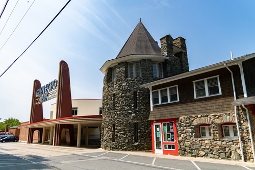 Rock Formation
Chautauqua Tower
 Beach
Tidal Basin Bathing Beach
 Botanical Garden
United States Botanic Garden
 Botanical Garden
Bartholdi Park
 Botanical Garden
Green Spring Gardens Park
 Botanical Garden
United States National Arboretum
 Lake
Kingman Lake
 Botanical Garden
Meadowlark Botanical Gardens
 Waterfall
Great Falls
 Canyon
Mather Gorge
Tips for scenic drive photography
- Drive the route in both directions — the views change completely.
- Plan stops for golden hour at the highest overlooks; use pull-outs, never stop on the roadway.
- Check seasonal closures for high-elevation roads before you go.
- A polarizer cuts windshield-like glare on wet roads and foliage.