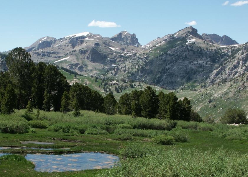
Located in Elko County, Nevada, Ruby Mountains Wilderness is a wilderness area. It is part of Humboldt–Toiyabe National Forest. It sits roughly 22 km (14 mi) SE of Spring Creek.
The Ruby Mountains Wilderness is a protected wilderness area in the Ruby Mountains of Elko County, Nevada, United States. It covers an area of approximately 90,000 acres (36,000 ha), and is administered by the Humboldt–Toiyabe National Forest. Ruby Mountains Wilderness contains hiking trails ranging between 9,000 and 10,000 feet in elevation. Hiking destinations include Seitz Canyon and the Lamoille Lake Trail.From the Wikipedia article “Ruby Mountains Wilderness”, licensed under CC BY-SA 4.0.
Sunrise & sunset directions
At Ruby Mountains Wilderness the sunrise point swings a long way through the year: about 58° (ENE) at the June solstice and 121° (ESE) in late December. Sunset moves from 303° (WNW) in June to 239° (WSW) in December, and the midday sun climbs to 73° in summer but only 26° in winter.
| Date | Sunrise | Azimuth | Sunset | Azimuth | Noon sun | Daylight |
|---|---|---|---|---|---|---|
| March equinox (Mar 20) | 6:46 AM | 90° E | 6:54 PM | 271° W | 49° | 12h 08m |
| June solstice (Jun 21) | 5:12 AM | 58° ENE | 8:17 PM | 303° WNW | 73° | 15h 05m |
| September equinox (Sep 22) | 6:30 AM | 89° E | 6:40 PM | 271° W | 50° | 12h 11m |
| December solstice (Dec 21) | 7:03 AM | 121° ESE | 4:18 PM | 239° WSW | 26° | 9h 16m |
Azimuth is measured clockwise from true north (90° = east, 270° = west). Computed for 2026; values change by less than a degree from year to year.
Golden hour & blue hour by month
Wilderness areas reward those who camp: being on location at sunrise and in the dark is the main advantage over day visitors.
| Month (15th) | Blue hour starts | Sunrise | Golden hour ends | Golden hour starts | Sunset | Blue hour ends | Daylight |
|---|---|---|---|---|---|---|---|
| January | 6:34 AM | 7:04 AM | 7:46 AM | 3:57 PM | 4:39 PM | 5:09 PM | 9h 36m |
| February | 6:08 AM | 6:36 AM | 7:14 AM | 4:39 PM | 5:17 PM | 5:45 PM | 10h 41m |
| March | 6:27 AM | 6:54 AM | 7:30 AM | 6:13 PM | 6:49 PM | 7:16 PM | 11h 55m |
| April | 5:35 AM | 6:04 AM | 6:40 AM | 6:44 PM | 7:21 PM | 7:49 PM | 13h 17m |
| May | 4:55 AM | 5:26 AM | 6:05 AM | 7:13 PM | 7:52 PM | 8:23 PM | 14h 26m |
| June | 4:38 AM | 5:11 AM | 5:52 AM | 7:34 PM | 8:15 PM | 8:48 PM | 15h 04m |
| July | 4:52 AM | 5:24 AM | 6:04 AM | 7:32 PM | 8:12 PM | 8:44 PM | 14h 48m |
| August | 5:24 AM | 5:53 AM | 6:31 AM | 7:03 PM | 7:41 PM | 8:10 PM | 13h 48m |
| September | 5:56 AM | 6:23 AM | 6:59 AM | 6:16 PM | 6:52 PM | 7:20 PM | 12h 29m |
| October | 6:26 AM | 6:53 AM | 7:30 AM | 5:26 PM | 6:03 PM | 6:30 PM | 11h 10m |
| November | 6:00 AM | 6:29 AM | 7:10 AM | 3:45 PM | 4:25 PM | 4:55 PM | 9h 56m |
| December | 6:28 AM | 6:59 AM | 7:43 AM | 3:33 PM | 4:16 PM | 4:47 PM | 9h 17m |
Local time (America/Los Angeles), including daylight saving time. Golden hour runs from about −4° to +6° solar altitude, so the morning golden hour begins during blue hour, before sunrise.
Milky Way & night sky
From Ruby Mountains Wilderness, the Milky Way core is visible in a dark sky from March through September. June gives the longest window (about 4.7 hours on a moonless night), and the core peaks around 21° above the southern horizon. Our light-pollution model puts the sky at about Bortle 2 (typical truly dark site), which is excellent for astrophotography.
| Month | Core visible (15th) | Hours | Max altitude | Direction |
|---|---|---|---|---|
| January | Below 10° in darkness | — | -2° | — |
| February | 4:59 AM – 4:59 AM | 0.0 | 11° | SE → SE |
| March | 4:10 AM – 5:20 AM | 1.2 | 17° | SE → SSE |
| April | 2:09 AM – 4:19 AM | 2.2 | 20° | SE → S |
| May | 12:04 AM – 3:24 AM | 3.3 | 21° | SE → S |
| June | 10:20 PM – 3:00 AM | 4.7 | 21° | SSE → SSW |
| July | 10:11 PM – 1:41 AM | 3.5 | 21° | S → SW |
| August | 9:24 PM – 11:34 PM | 2.2 | 20° | S → SW |
| September | 8:25 PM – 9:35 PM | 1.2 | 17° | SSW → SW |
| October | 7:34 PM – 7:34 PM | 0.0 | 11° | SW → SW |
| November | Below 10° in darkness | — | -1° | — |
| December | Below 10° in darkness | — | -19° | — |
Window when the galactic core is at least 10° high during astronomical darkness on the 15th of each month. Pick nights within a few days of the new moon. Plan exact nights with the Milky Way planner.
Estimated sky darkness: 2 Bortle 2 — Typical truly dark site. The summer Milky Way shows rich structure; clouds look like black holes in the stars. Modeled zenith brightness ≈ 21.87 mag/arcsec². Aurora needs roughly Kp 7.5+ to show low on the northern horizon here.
Weather & best season
Long-term NASA satellite data for this area show September as the clearest month (about 31% average cloud cover) and December as the cloudiest (69%). July is the warmest month and January the coldest, which matters for gear, snow access and how long batteries last at night.
Average cloud cover (%)
| Jan | Feb | Mar | Apr | May | Jun | Jul | Aug | Sep | Oct | Nov | Dec | |
|---|---|---|---|---|---|---|---|---|---|---|---|---|
| High °F | 62 | 64 | 73 | 81 | 92 | 98 | 100 | 98 | 95 | 83 | 70 | 54 |
| Low °F | -18 | -6 | -1 | 15 | 19 | 27 | 42 | 40 | 26 | 8 | -8 | -21 |
| Precip. (in) | 1.6 | 1.4 | 1.7 | 2.3 | 1.7 | 0.7 | 0.5 | 0.5 | 1.0 | 1.0 | 1.4 | 2.0 |
Monthly climatology for the surrounding 1° grid cell from NASA POWER (MERRA-2). Mountain sites can be colder and cloudier than the cell average.
Photography tips for this wilderness area
- Group size limits and permits may apply; check with the managing agency.
- Practice Leave No Trace — camp on durable surfaces away from lakes and streams.
- Pack weight matters: a single zoom and a light tripod cover most situations.
- Night skies are often among the darkest in the country.
- Motorized and mechanized equipment, including drones, is prohibited in designated wilderness.
- Tell someone where you're going in remote areas and carry the ten essentials.
Season: Most high wilderness is snow-free from July to September; lower deserts are best in spring and autumn.
Suggested gear: Lightweight tripod, Spare batteries, Headlamp, Navigation. Work out exposures with the depth of field, ND filter and NPF rule calculators.
Permits, drones & access
Drones: Drones may not take off from or land in federally designated wilderness, where mechanized equipment is prohibited under the Wilderness Act.
Nearby photo spots
Other locations within 40 km of Ruby Mountains Wilderness, closest first.
 Lake
 Lake
 Lake
 Lake
 Mountain Peak
 Lake
 Lake
 Lake
 Canyon
Campgrounds nearby (Recreation.gov)
- Terraces Campground - Picnic Area6.1 km (3.8 mi) · reservable
- Thomas Canyon7.4 km (4.6 mi) · reservable
- Powerhouse Group Picnic Area12.6 km (7.8 mi) · reservable
FAQ
When is the best time to photograph Ruby Mountains Wilderness?
What time is golden hour at Ruby Mountains Wilderness?
Where does the sun rise and set at Ruby Mountains Wilderness?
Can you see the Milky Way from Ruby Mountains Wilderness?
Do you need a permit to photograph at Ruby Mountains Wilderness?
How far is Ruby Mountains Wilderness from Spring Creek?
Sources
Location data: Wikidata, Wikipedia. Sun, moon and Milky Way times are computed by LWPhoto Atlas for 2026. Climate: NASA POWER. Sky darkness is a population-based estimate (Walker's law), not a measurement. See data sources & licenses.