
North Furlong Lake is a lake in Elko County, Nevada at about 2,924 m (9,593 ft) above sea level. The nearest town is Spring Creek, about 24 km (15 mi) away (North Furlong Lake lies SE of town).
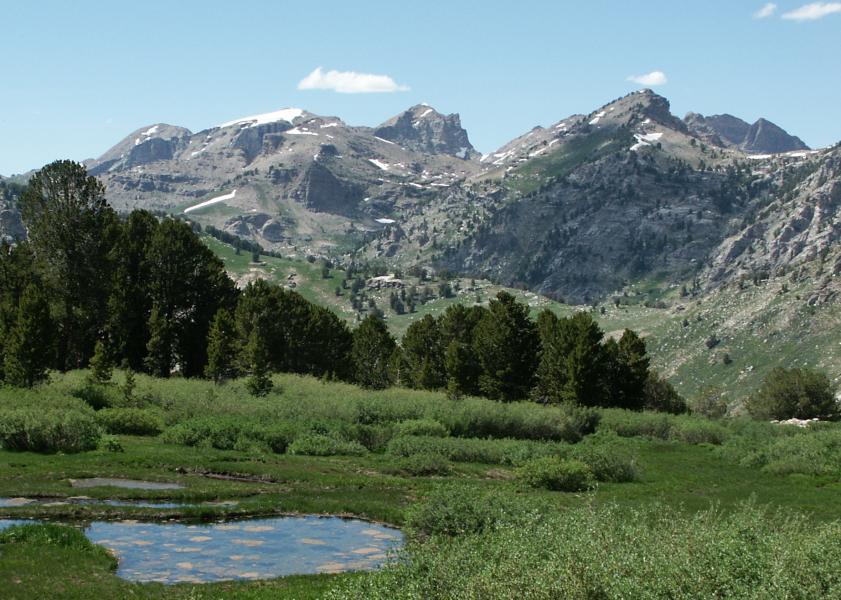
North Furlong Lake is a glacial tarn in the Ruby Mountains, in Elko County in the northeastern part of the state of Nevada. It is located at the head of North Furlong Canyon at approximately 40°33.4′N 115°24.8′W, and at an elevation of 9,590 feet (2,920 meters). It has an area of approximately 16 acres (6.5 hectares), and a depth of up to 20 feet (6.1 meters). This is a common camp for users of the Ruby Crest National Recreation Trail, which passes nearby. North Furlong Lake is the primary source of North Furlong Creek, which after exiting the mountains merges with other streams to form the South Fork of the Humboldt River.From the Wikipedia article “North Furlong Lake (Nevada)”, licensed under CC BY-SA 4.0.
Sunrise & sunset directions
At North Furlong Lake the sunrise point swings a long way through the year: about 58° (ENE) at the June solstice and 121° (ESE) in late December. Sunset moves from 303° (WNW) in June to 239° (WSW) in December, and the midday sun climbs to 73° in summer but only 26° in winter.
| Date | Sunrise | Azimuth | Sunset | Azimuth | Noon sun | Daylight |
|---|---|---|---|---|---|---|
| March equinox (Mar 20) | 6:46 AM | 90° E | 6:54 PM | 271° W | 49° | 12h 08m |
| June solstice (Jun 21) | 5:12 AM | 58° ENE | 8:17 PM | 303° WNW | 73° | 15h 05m |
| September equinox (Sep 22) | 6:30 AM | 89° E | 6:40 PM | 271° W | 50° | 12h 11m |
| December solstice (Dec 21) | 7:03 AM | 121° ESE | 4:19 PM | 239° WSW | 26° | 9h 16m |
Azimuth is measured clockwise from true north (90° = east, 270° = west). Computed for 2026; values change by less than a degree from year to year.
Golden hour & blue hour by month
Lakes reflect best in calm air — usually the first hour after sunrise, before breezes ripple the surface.
| Month (15th) | Blue hour starts | Sunrise | Golden hour ends | Golden hour starts | Sunset | Blue hour ends | Daylight |
|---|---|---|---|---|---|---|---|
| January | 6:34 AM | 7:04 AM | 7:46 AM | 3:58 PM | 4:40 PM | 5:10 PM | 9h 36m |
| February | 6:08 AM | 6:36 AM | 7:14 AM | 4:39 PM | 5:17 PM | 5:45 PM | 10h 41m |
| March | 6:27 AM | 6:54 AM | 7:30 AM | 6:13 PM | 6:49 PM | 7:16 PM | 11h 55m |
| April | 5:35 AM | 6:04 AM | 6:40 AM | 6:44 PM | 7:21 PM | 7:49 PM | 13h 17m |
| May | 4:55 AM | 5:26 AM | 6:05 AM | 7:13 PM | 7:52 PM | 8:23 PM | 14h 26m |
| June | 4:38 AM | 5:11 AM | 5:52 AM | 7:34 PM | 8:15 PM | 8:48 PM | 15h 03m |
| July | 4:52 AM | 5:24 AM | 6:05 AM | 7:32 PM | 8:12 PM | 8:44 PM | 14h 48m |
| August | 5:24 AM | 5:53 AM | 6:31 AM | 7:03 PM | 7:41 PM | 8:10 PM | 13h 48m |
| September | 5:56 AM | 6:23 AM | 6:59 AM | 6:16 PM | 6:52 PM | 7:20 PM | 12h 29m |
| October | 6:26 AM | 6:53 AM | 7:30 AM | 5:26 PM | 6:03 PM | 6:30 PM | 11h 10m |
| November | 6:00 AM | 6:29 AM | 7:10 AM | 3:45 PM | 4:25 PM | 4:55 PM | 9h 56m |
| December | 6:28 AM | 6:59 AM | 7:42 AM | 3:33 PM | 4:16 PM | 4:47 PM | 9h 17m |
Local time (America/Los Angeles), including daylight saving time. Golden hour runs from about −4° to +6° solar altitude, so the morning golden hour begins during blue hour, before sunrise.
Milky Way & night sky
From North Furlong Lake, the Milky Way core is visible in a dark sky from March through September. June gives the longest window (about 4.7 hours on a moonless night), and the core peaks around 21° above the southern horizon. Our light-pollution model puts the sky at about Bortle 2 (typical truly dark site), which is excellent for astrophotography.
| Month | Core visible (15th) | Hours | Max altitude | Direction |
|---|---|---|---|---|
| January | Below 10° in darkness | — | -2° | — |
| February | 4:59 AM – 4:59 AM | 0.0 | 11° | SE → SE |
| March | 4:10 AM – 5:20 AM | 1.2 | 17° | SE → SSE |
| April | 2:09 AM – 4:19 AM | 2.2 | 20° | SE → S |
| May | 12:04 AM – 3:24 AM | 3.3 | 21° | SE → S |
| June | 10:20 PM – 3:00 AM | 4.7 | 21° | SSE → SSW |
| July | 10:11 PM – 1:41 AM | 3.5 | 21° | S → SW |
| August | 9:24 PM – 11:34 PM | 2.2 | 20° | S → SW |
| September | 8:25 PM – 9:35 PM | 1.2 | 17° | SSW → SW |
| October | 7:34 PM – 7:34 PM | 0.0 | 11° | SW → SW |
| November | Below 10° in darkness | — | -1° | — |
| December | Below 10° in darkness | — | -19° | — |
Window when the galactic core is at least 10° high during astronomical darkness on the 15th of each month. Pick nights within a few days of the new moon. Plan exact nights with the Milky Way planner.
Estimated sky darkness: 2 Bortle 2 — Typical truly dark site. The summer Milky Way shows rich structure; clouds look like black holes in the stars. Modeled zenith brightness ≈ 21.88 mag/arcsec². Aurora needs roughly Kp 8.0+ to show low on the northern horizon here.
Weather & best season
Long-term NASA satellite data for this area show September as the clearest month (about 31% average cloud cover) and December as the cloudiest (69%). July is the warmest month and January the coldest, which matters for gear, snow access and how long batteries last at night.
Average cloud cover (%)
| Jan | Feb | Mar | Apr | May | Jun | Jul | Aug | Sep | Oct | Nov | Dec | |
|---|---|---|---|---|---|---|---|---|---|---|---|---|
| High °F | 62 | 64 | 73 | 81 | 92 | 98 | 100 | 98 | 95 | 83 | 70 | 54 |
| Low °F | -18 | -6 | -1 | 15 | 19 | 27 | 42 | 40 | 26 | 8 | -8 | -21 |
| Precip. (in) | 1.6 | 1.4 | 1.7 | 2.3 | 1.7 | 0.7 | 0.5 | 0.5 | 1.0 | 1.0 | 1.4 | 2.0 |
Monthly climatology for the surrounding 1° grid cell from NASA POWER (MERRA-2). Mountain sites can be colder and cloudier than the cell average.
Photography tips for this lake
- For mirror reflections, get low and close to the water; the reflection grows with a lower camera.
- A polarizer can remove reflections to show the lakebed — or keep them, depending on rotation.
- Mist often lifts off lakes on cold mornings after warm days, especially in autumn.
- Include shoreline rocks, reeds or a log as foreground to give the reflection depth.
- Check road and trail conditions with the managing agency before you go.
Season: Autumn mornings bring mist and fall color; high-elevation lakes are usually ice-free only from early summer to mid-autumn.
Suggested gear: Tripod, Circular polarizer, Wide-angle lens, Waterproof boots. Work out exposures with the depth of field, ND filter and NPF rule calculators.
Nearby photo spots
Other locations within 25 km of North Furlong Lake, closest first.
 Lake
 Lake
 Lake
 Wilderness Area
 Lake
 Mountain Peak
 Lake
 Lake
 Canyon
Campgrounds nearby (Recreation.gov)
- Terraces Campground - Picnic Area9.2 km (5.7 mi) · reservable
- Thomas Canyon10.4 km (6.5 mi) · reservable
- Powerhouse Group Picnic Area14.9 km (9.3 mi) · reservable
FAQ
When is the best time to photograph North Furlong Lake?
What time is golden hour at North Furlong Lake?
Where does the sun rise and set at North Furlong Lake?
Can you see the Milky Way from North Furlong Lake?
Do you need a permit to photograph at North Furlong Lake?
How far is North Furlong Lake from Spring Creek?
Sources
Location data: Wikidata, USGS GNIS / GeoNames, Wikipedia. Sun, moon and Milky Way times are computed by LWPhoto Atlas for 2026. Climate: NASA POWER. Sky darkness is a population-based estimate (Walker's law), not a measurement. See data sources & licenses.