Top waterfalls
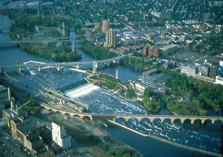 Waterfall
Saint Anthony Falls
 Waterfall
Minnehaha Falls
 Waterfall
Hidden Falls
 Waterfall
Winnewissa Falls
 Waterfall
Devil's Kettle
 Waterfall
Como Falls Park
 Waterfall
Minneopa Falls
WaterfallAsh River Falls
WaterfallBasswood Falls
WaterfallBeaver River Falls
WaterfallBig Spring Falls
WaterfallCaribou Falls
Waterfalls by county
All waterfalls (48)
| Name | County | Elevation | Nearest town | Sky |
|---|---|---|---|---|
| Saint Anthony Falls | Hennepin County | 241 m | Minneapolis | 8 |
| Minnehaha Falls | Hennepin County | 247 m | Longfellow Community | 8 |
| Hidden Falls | Hennepin County | — | Longfellow Community | 7 |
| Winnewissa FallsPipestone | Pipestone County | 516 m | Pipestone | 4 |
| Devil's Kettle | Cook County | — | Grand Marais | 1 |
| Como Falls Park | Houston County | — | La Crescent | 5 |
| Minneopa Falls | Blue Earth County | — | North Mankato | 5 |
| Ash River FallsVoyageurs | Saint Louis County | 345 m | International Falls | 1 |
| Basswood Falls | Lake County | 399 m | Ely | 1 |
| Beaver River Falls | Lake County | 228 m | Silver Bay | 1 |
| Big Spring Falls | Pine County | 290 m | Sandstone | 4 |
| Caribou Falls | Lake County | 233 m | Silver Bay | 1 |
| Cascade Falls | Cook County | 199 m | Grand Marais | 1 |
| Chipmunk Falls | Saint Louis County | 366 m | Virginia | 1 |
| Curtain Falls | Saint Louis County | 384 m | Ely | 1 |
| Deadmans Rapids | Koochiching County | 348 m | International Falls | 1 |
| Devils Cascade | Saint Louis County | 368 m | Ely | 1 |
| Fiftysix Rapids | Saint Louis County | 344 m | Ely | 1 |
| Glenn Avon Falls | Lake County | 278 m | Silver Bay | 1 |
| Gooseberry Falls | Lake County | 201 m | Two Harbors | 2 |
| Hannine Falls | Saint Louis County | 384 m | Chisholm | 1 |
| Hidden Falls | Cook County | 215 m | Silver Bay | 1 |
| Illgen Falls | Lake County | 283 m | Silver Bay | 1 |
| Johnson Falls | Cook County | 476 m | Grand Marais | 1 |
| Kettle FallsVoyageurs | Saint Louis County | 340 m | International Falls | 1 |
| Koochiching Falls | Koochiching County | 334 m | International Falls | 5 |
| Last Falls | Lake County | 383 m | Ely | 1 |
| Little American Falls | Koochiching County | 378 m | Hibbing | 1 |
| Little Rock Falls | Cook County | 463 m | Grand Marais | 1 |
| Loon Falls | Saint Louis County | 353 m | Ely | 1 |
| Lower Basswood Falls | Lake County | 382 m | Ely | 1 |
| Middle Falls | Cook County | 243 m | Houghton | 1 |
| Minnemishinona Falls | Nicollet County | 251 m | North Mankato | 5 |
| Minnesota Falls | Yellow Medicine County | 268 m | Granite Falls | 4 |
| Minnewankon Falls | Nicollet County | 258 m | North Mankato | 5 |
| Newton Falls | Lake County | 399 m | Ely | 2 |
| Pancake Falls | Lake County | 441 m | Silver Bay | 1 |
| Partridge FallsGrand Portage | Cook County | 400 m | Grand Marais | 1 |
| Pigeon Falls | Cook County | 209 m | Houghton | 1 |
| Pike River Falls | Saint Louis County | 415 m | Aurora | 1 |
| Pipestone Falls | Lake County | 399 m | Ely | 1 |
| Portage Falls | Cook County | 473 m | Grand Marais | 1 |
| Ramsey Falls | Redwood County | 286 m | Redwood Falls | 5 |
| Saganaga Falls | Cook County | 439 m | Virginia | 1 |
| Shadow Falls | Ramsey County | 255 m | Longfellow Community | 8 |
| Sioux Falls | Saint Louis County | 415 m | Ely | 1 |
| Wheelbarrow Falls | Lake County | 385 m | Ely | 1 |
| Wolf Creek Falls | Pine County | 295 m | Sandstone | 4 |
Sky = estimated Bortle class (1 darkest – 9 brightest).
Map
How to photograph waterfalls
Waterfalls photograph best in soft, even light: overcast days, deep shade, or the hour after sunrise before direct sun hits the water. Bright sun on white water blows highlights and adds harsh contrast.
- Use 1/4 to 1 second for a silky look; 1/500 s or faster freezes individual drops.
- A circular polarizer cuts glare on wet rocks and leaves and deepens greens — rotate it while watching the rocks, not the sky.
- Spring snowmelt and the days after heavy rain give the strongest flow; late summer flow can drop to a trickle.
- Look for a foreground: a mossy boulder, a fallen log or the creek's leading lines make a stronger frame than the falls alone.
- Keep a microfiber cloth handy — spray drifts onto the lens, especially at the plunge pool.
Season: Peak flow is usually in late spring; autumn adds color around the falls, and winter can bring ice formations at colder locations.